What if your morning run, a quick paddle, and a walk to coffee could all start from your front door? In Natick, water and trail access are part of everyday life, not just a weekend plan. If you love lakes, rivers, and bike paths, you will find plenty here to shape your routine and your home search. This guide shows you where to go, how the network fits together, and what to check before you buy. Let’s dive in.
Outdoor essentials at a glance
Natick’s outdoor appeal comes from a tight mix of water, trails, and town access. Here are the anchors you will use most:
- Lake Cochituate inside Cochituate State Park, with swimming areas, non-motorized boating, a boat ramp, rentals, and seasonal parking rules. See current rules on the Cochituate State Park page.
- The Charles River in South Natick, a scenic paddling corridor with small public launches and active stewardship, plus regional events through the Charles River Watershed Association.
- A town-wide trail system, including the paved Cochituate Rail Trail (CRT) and many local connectors that link neighborhoods to parks and downtown. Explore the town’s interactive trails map for trailheads and connections.
Lake Cochituate: swim, paddle, unwind
Lake Cochituate is three connected basins with a state-managed beach, boat ramp, rentals, and picnic spots. You can swim, kayak, canoe, and, per park guidance, waterski or tube on South Lake. Summer is popular and the state enforces parking and capacity, so plan ahead on sunny weekends. Review what is open and when on the Cochituate State Park page.
You will also find short footpaths like the Snake Brook Trail and shoreline spots for quick views. A planned shared-use connection called the Lake Cochituate Path aims to link west-side neighborhoods to the CRT and Route 9. The project timeline is set by the state and can shift; track updates on the Lake Cochituate Path project page.
Charles River and South Natick village
South Natick’s riverfront centers on the spillway near the Bacon Free Library. The town is advancing a dam removal and river restoration that will change how the immediate shoreline looks and functions. Town materials discuss a removal window in summer 2026, with related park work that may alter short-term access and paddling conditions. You can follow status and meeting notes on the dam removal and restoration page.
For paddling days, Elm Bank Reservation on the Wellesley and Dover line offers a maintained launch and gardens to explore. Parking and carry distances vary by site, so plan your put-in before you go. Learn about the reservation on the MassHort Elm Bank page.
Trails that make life easy
The Cochituate Rail Trail is a roughly 3 to 4 mile paved path that links Saxonville in Framingham to neighborhoods near Natick Center. It passes close to Lake Cochituate and connects to parks, school fields, and retail. You will see families biking, runners training, and commuters using the route for quick trips.
Beyond the CRT, small connectors and unpaved paths stitch neighborhoods together. Segments on the Sudbury Aqueduct, town forest trails, and loops around local ponds help you reach fields and parks without a car. For exact trailheads and last-mile links to downtown, use the interactive trails map.
Daily routines you can count on
Outdoor life in Natick is built around short, frequent outings. Here are common ways residents use the network:
- A 20-minute walk to the CRT for a stroller-friendly loop.
- After-work paddles on Lake Cochituate for kayaks and SUPs.
- Weekend bike rides that include a coffee stop or errands near Route 9.
- Season-based shifts. Summer is busiest on the lake for swimming and rentals. Fall and spring are ideal for trail runs and longer rides. Winter activities depend on local safety advisories.
Community events make the outdoors feel social and well cared for. Regional paddling events and cleanups through the Charles River Watershed Association and local trail volunteer days keep access points in good shape.
Transit and the CRT: easy multimodal commutes
Two MBTA Commuter Rail stations serve Natick on the Framingham/Worcester line: Natick Center and West Natick. Recent accessibility work at Natick Center and short CRT connections make bike-to-rail trips more practical for many riders. Map your door-to-station route and check the latest station connectivity on the town’s Transit page.
Neighborhood patterns near water and trails
- South Natick and the Charles River corridor feature a compact village center and a range of older, often larger homes. Public river access points are limited in spots. The active river restoration may change immediate shoreline character over time.
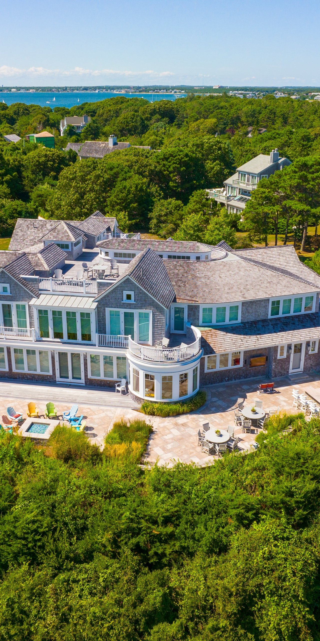
- Around Lake Cochituate you will see year-round waterfront homes alongside nearby mid-century streets. Waterfront lots often carry a premium due to direct access and views, and inventory can be limited.
- Natick Center offers a walkable downtown with condos and mixed-use buildings close to the updated commuter rail. Buyers who want a quick walk to coffee and a short hop to the CRT often focus here.
- West Natick and the Route 9 corridor include denser housing and retail. Smaller, lower-maintenance homes near CRT spurs and shopping make daily errands simple.
Buyer checklist for water-and-trail homes
Use this quick list to focus your due diligence:
- Confirm public vs. private water access. Check whether nearby shoreline is town land, state park, or private. The town’s interactive trails map and the Cochituate State Park page identify official access points and parking.
- Ask about dock rights and permits. Shoreline structures often require local conservation review and state rules. Start with the town and DCR for current guidance.
- Review flood risk and insurance. Low-lying areas near the Charles and local ponds can see localized flooding. The town’s river restoration page offers context on mitigation and modeling. Pair that with FEMA maps for the exact lot.
- Check water quality advisories. Massachusetts ponds and beaches can close for bacteria or cyanobacteria in warm months. For river conditions, see the Charles River red-flag system and advisories through the Mass Rivers Alliance.
- Understand septic vs. sewer. Many older lakeside and South Natick homes may use septic. Ask for inspection records and confirm sewer availability with the town.
- Expect seasonality and event activity. State park lots and CRT trailheads are busiest on weekends and event days. Proximity boosts walkability but can increase foot and bike traffic at peak times.
How to choose your spot
Start by ranking what you will use most. If swimming and summer beach days top the list, look close to state park access and plan for seasonal parking on busy weekends. If your goal is a daily bike commute, focus on direct CRT connectors and a clear route to the rail station. For paddlers, list your preferred put-ins and confirm parking and carry distances before you buy.
Next, line up logistics. Verify shoreline rules if a listing mentions dock potential. Ask about floodplain status, utility details, and any conservation restrictions along the lot line. When in doubt, use the town’s maps and project pages to confirm the latest information.
Ready to explore homes that match the way you live outside? If you want an advisor who knows the trails, river access points, and neighborhood patterns, connect with Teri Adler for thoughtful guidance and a streamlined search.
FAQs
What is it like to live on Lake Cochituate in Natick?
- You can expect quick access to paddling and swimming, a lively summer shoreline, and added due diligence on dock rights, insurance, and maintenance compared with inland homes.
Can the Cochituate Rail Trail help me bike to the train?
- Yes. The CRT and short connectors make bike trips to Natick Center realistic for many riders, with recent station upgrades improving multimodal commutes.
Is the Charles River in South Natick good for kayaking?
- Yes, there are paddleable stretches with formal launches, though parking and carry distances vary. The planned dam removal will change immediate conditions near the spillway.
Do I need a permit for a private dock on local lakes or rivers?
- Often yes. Local conservation and state rules can apply, so confirm requirements with the town and DCR before planning any structure.
How busy do parks and trailheads get on weekends?
- Expect heavier use at Cochituate State Park and CRT trailheads during warm-weather weekends and community events, with parking and capacity rules enforced by managers.